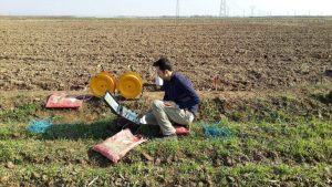
Finding a reliable source of clean groundwater can be a challenge. Geophysics offers a powerful tool to assist in groundwater exploration. This scientific discipline utilizes specialized techniques to study the Earth’s physical properties. By analyzing these properties geophysics can help us “see” beneath the surface revealing valuable information about the location and characteristics of potential water-bearing zones. This information is crucial for making informed decisions about well drilling leading to a higher success rate in finding clean sustainable groundwater.
Within the realm of geophysics one particularly valuable method for locating well sites is electrical resistivity (ER). This technique works by measuring how easily electricity travels through the Earth’s subsurface. Different materials such as water-saturated layers or dense bedrock have varying electrical resistance. By analyzing these variations geophysicists can create a kind of “map” of the subsurface pinpointing areas with high conductivity which often indicate the presence of groundwater. This information allows for targeted well drilling significantly increasing the chances of encountering a productive aquifer and ultimately leading to a successful well with a reliable source of clean water.
Benefits of Electrical Resistivity (ER) for Groundwater Exploration:
- Non-destructive and environmentally friendly: ER surveys are conducted on the surface and don’t require drilling or excavation minimizing environmental impact.
- Cost-effective: ER surveys are often cheaper compared to drilling multiple exploratory wells saving time and money.
- Rapid data acquisition: ER surveys can be conducted relatively quickly providing results faster than traditional methods.
- Detailed subsurface information: ER surveys provide valuable information about subsurface layers including thickness, depth, and potential water content.
- Identifies both freshwater and saline water: ER can distinguish between freshwater and saline water layers helping to avoid drilling into unusable saline zones.
- Effective in various terrains: ER surveys work well in a variety of geological settings from flat plains to rugged landscapes.
- Targets well drilling locations: ER data helps pinpoint areas with high water potential increasing the success rate of well drilling.
- Minimizes risk of encountering unexpected obstacles: ER surveys can identify potential problems like buried pipes or unstable layers allowing for informed planning.
- Provides data for well design and construction: ER information can be used to determine the optimal depth and construction materials for a well.
These benefits make ER a valuable tool for anyone involved in groundwater exploration from individual landowners to large-scale water management projects.

